MUNICIPALITY

​Local Government in South Africa consists of municipalities of various types. The largest metropolitan areas are governed by metropolitan municipalities, while the rest of the country is divided into district municipalities, each of which consist of several local municipalities.

Municipalities are governed by municipal councils which are elected every five years. Municipalities can belong to one of three categories: Metropolitan, district and local. In areas which are primarily rural, the local government is divided into district municipalities and local municipalities.

District Municipalities are the main divisions of South Africa's provinces; they are subdivided into local municipalities. Local municipalities share authority with the district municipality under which they fall. Metropolitan and district municipalities form the layer of government directly below the provinces.

The Eastern Cape local government sector is constituted by the two Metropolitan Municipalities (Buffalo City and Nelson Mandela Bay) and five district municipalities (Alfred Nzo, Amathole, Cacadu, Chris Hani and O.R. Tambo District Municipality).

​Alfred Nzo District is located on the north-eastern side of the Eastern Cape Province and stretches from the Drakensberg Mountains, borders Lesotho in the North, Sisonke District Municipality in the East and O.R. Tambo District Municipality in the South. Visit website : http://www.andm.gov.za/" The district has four local municipalities namely:
  • Matatiele Municipality
  • Umzimvubu Local Municipality
  • Mbizana-Local-Municipality
  • Ntabankulu-Local-Municipality

Amathole District Municipality is situated in the central part of the Eastern Cape stretching along the Sunshine Coast from the Fish River Mouth, along the Eastern Seaboard to just south of Hole in the Wall along the Wild Coast. It is bordered to the north by the Amathole Mountain Range. It is comprised of eight local municipalities:
  • Amahlathi Local Municipality
  • Buffalo City Local Municipality
  • Great Kei Local Municipality
  • Mbhashe Local Municipality
  • Mnquma Local Municipality
  • Ngqushwa Local Municipality
  • Nkonkobe Local Municipality
  • Nxuba Local Municipality
Cacadu District Municipality is stretching from Graaff-Reinet in the north to the Indian Ocean in the south, and between the Bloukrans River in the west and Great Fish River in the east. It comprises ten local municipalities:
  • Baviaans
  • Blue Crane Route
  • Camdeboo
  • Ikhwezi
  • Kouga
  • Kou-Kamma
  • Makana
  • Ndlambe
  • Sundays River Valley
Chris Hani District Municipality is situated in the heart of the Eastern Cape, and is a linking node to all the regions in the province. It comprises eight local municipalities:
  • Emalahleni
  • Engcobo
  • Inkwanca
  • Intsika Yethu
  • Inxuba Yethemba
  • Lukhanji
  • Sakhisizwe
  • Tsolwana
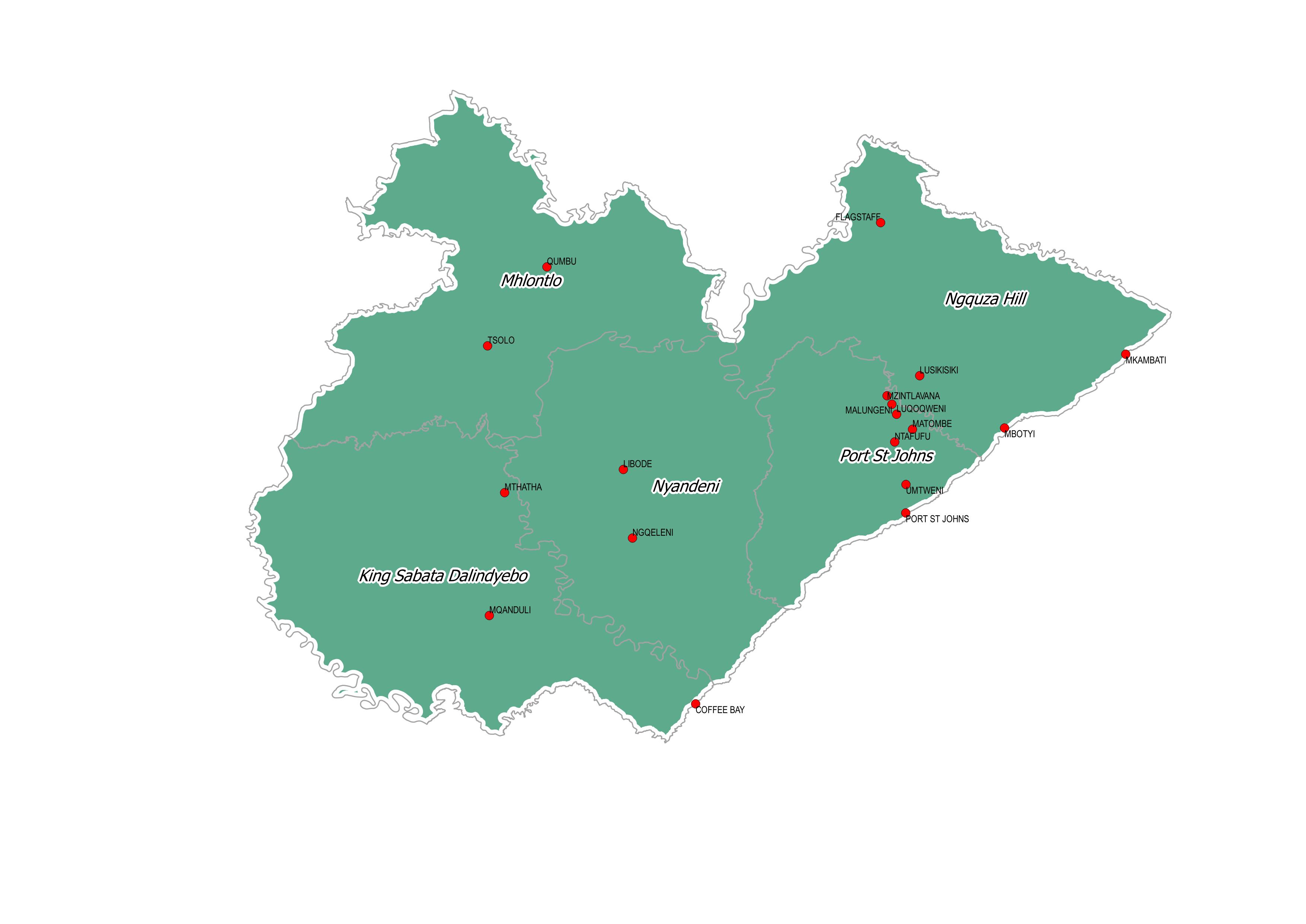
OR Tambo District Municipality is one of the six district municipalities and one of the four ISRDP nodes of the Eastern Cape Province. It covers about 80% of what used to be marginalised homeland in Transkei and is formed by five local municipalities:
    King Sabata Dalindyebo
  • Nyandeni
  • Mhlontlo
  • Port St Johns
  • Ingquza Hill
The municipality is located to the east of the Eastern Cape Province, on the Indian Ocean coastline. It is bordered by the Alfred Nzo District Municipality to the north, the Joe Gqabi District Municipality to the north-west, the Chris Hani District Municipality to the west and the Amathole District Municipality to the south-west
Joe Gqabi District Municipality, previously known asUkhahlamba District Municipality, borders the Free State province and country of Lesotho to the north. It lies approximately 34km north of Queenstown and its northern border is formed by the Orange River, which also forms the southern boundary of the Free State. It consists of four local municipalities:
  • Elundini
  • Gariep
  • Maletswai
  • Senqu
© 2021 - 2023 Office of the Premier, Eastern Cape 
logo